


New

Original price was: $20.99.$14.69Current price is: $14.69.
- Worry-Free Shopping with Safe Payments
- Product guarantee 100% satisfaction
- Quality products, fair prices.
- Safe and Secure Shopping

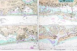
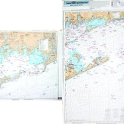
Captain Seagull’s Coast of CT and North Shore of Long Island NY Inshore Nautical Chart is a an inshore chart 1-2 miles off the coast detailing the bays. Chart is 19 x 26 inches, double sided, and laminated.
Detailing the bays, covers western half of coast of Connecticut. West Haven, CT to NY border; North Coast of Long Island, NY . All charts include GPS coordinates, wrecks, reefs, shoals, fishing areas, amenities and restrictions.
Captain Seagull’s Coast of CT and North Shore of Long Island NY Inshore Nautical Chart – Model # NLI106
| Select Model | NLI106 |
|---|
Be the first to review “Maps / Charts Captain Seagull’s Coast Of CT And North Shore Of Long Island NY Inshore Nautical Chart”
Related products
New
Original price was: $16.99.$11.89Current price is: $11.89.
New

Original price was: $17.95.$12.57Current price is: $12.57.
New
Charts + Media
Original price was: $16.95.$11.87Current price is: $11.87.
New

Original price was: $20.99.$14.69Current price is: $14.69.
New

Charts + Media
Original price was: $21.95.$15.37Current price is: $15.37.
New
Original price was: $20.99.$14.69Current price is: $14.69.
New
Charts + Media
Original price was: $18.95.$13.27Current price is: $13.27.
New
Charts + Media
Original price was: $20.99.$14.69Current price is: $14.69.
Reviews
There are no reviews yet.